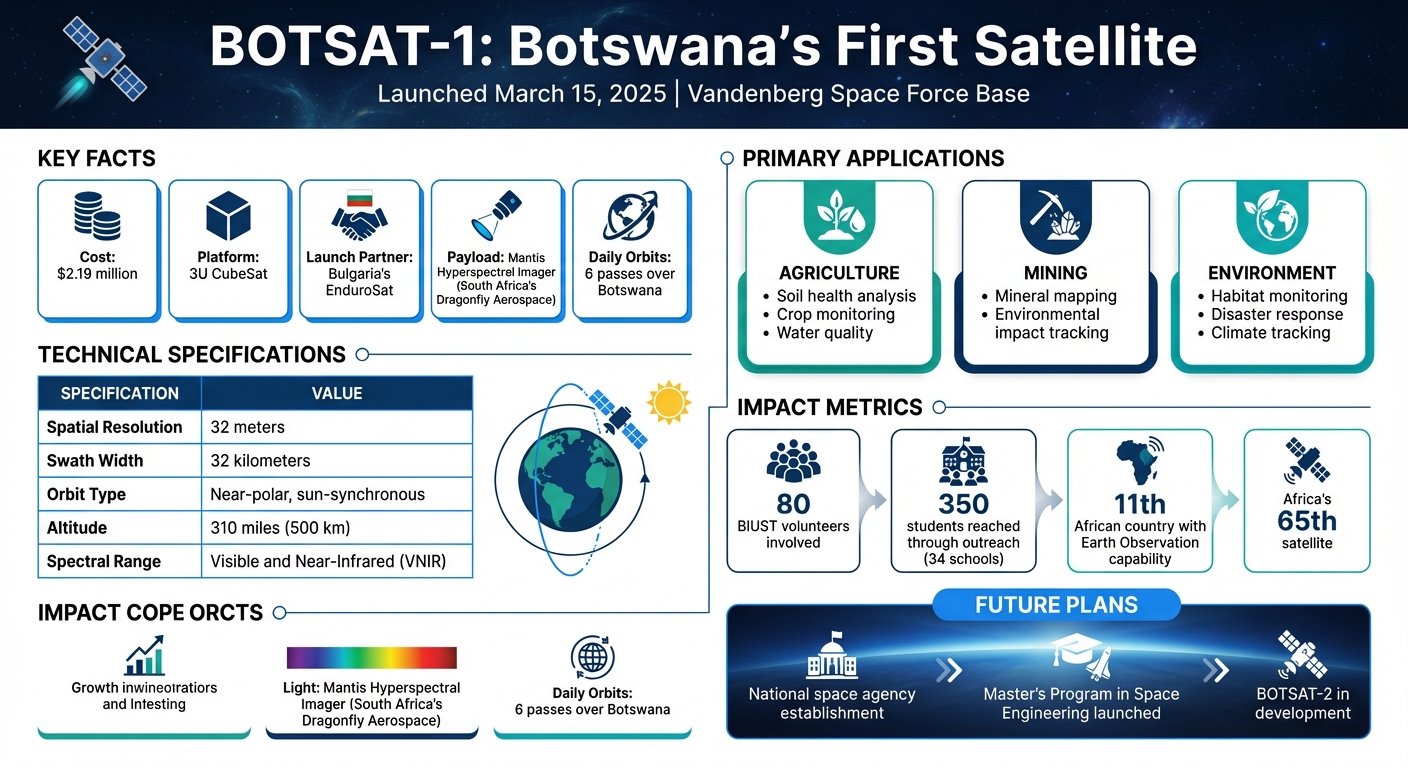
Botswana made history on March 15, 2025, with the launch of its first satellite, BOTSAT-1, from Vandenberg Space Force Base. Developed by the Botswana International University of Science and Technology (BIUST) for $2.19 million, this Earth Observation satellite is equipped with a hyperspectral camera to support agriculture, mining, and environmental monitoring. Key details include:
- Name: BOTSAT-1, symbolizing Botswana’s entry into space.
- Launch Partner: Bulgaria’s EnduroSat, providing a 3U CubeSat platform and training for BIUST engineers.
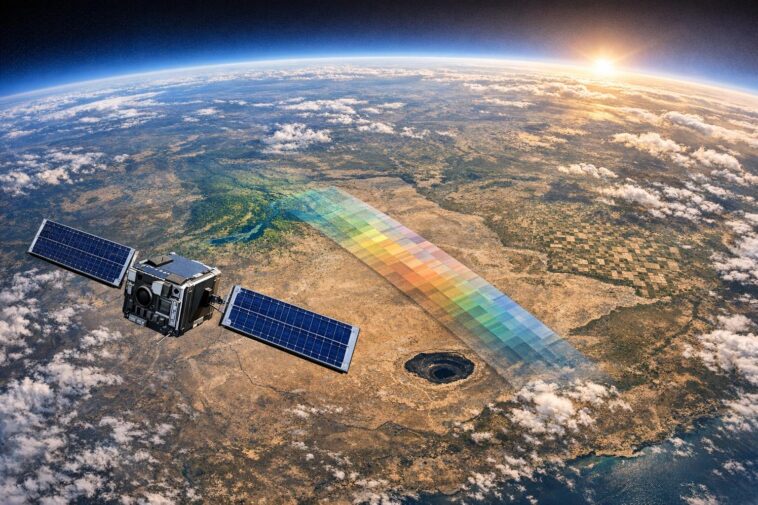
- Payload: Mantis Hyperspectral Imager from South Africa’s Dragonfly Aerospace; 32m resolution, 32km swath width.
- Orbit: Near-polar, sun-synchronous at 310 miles.
- Applications:
- Agriculture: Soil health analysis and crop monitoring.
- Mining: Mineral mapping and environmental impact tracking.
- Environmental Management: Habitat monitoring and disaster response.
This milestone has spurred Botswana to establish a national space agency, launch a Master’s program in space engineering, and plan for BOTSAT-2. The project highlights how resourceful planning and collaborations can drive space exploration in emerging nations.


BOTSAT-1 Satellite Technical Specifications and Key Facts
🚀 Botswana’s First Satellite Launch – Prof. Totolo Explains Historic Botsat 1 Mission! 🌍📡
BOTSAT-1: The Satellite’s Official Name
The official name of the satellite, BOTSAT-1, stands for "Botswana Satellite 1." This milestone marks Botswana’s formal entry into the global space community and signifies the beginning of the country’s space program. The "-1" in the name highlights its status as the first in a planned series of missions, with BOTSAT-2 already in development. This naming approach underscores Botswana’s long-term vision to establish and grow its own space capabilities. More than just a technical achievement, the project represents Botswana’s broader goal of transitioning to a knowledge-driven economy. It shows the nation’s ability to design and operate space infrastructure that aligns with its development priorities.
What the Name Represents
BOTSAT-1 is more than just a technical label – it holds deep symbolic value. The satellite’s first transmission to Earth was the Botswana national anthem in Setswana, a powerful gesture that reflects national pride and technological independence.
The name also embodies years of dedication and innovation by local engineers and scientists. Remarkably, this effort was achieved without a formal space agency or established space policy. As Raycho Raychev, Founder and CEO of EnduroSat, remarked:
"The fact that their organization has a long-term strategic growth vision, and that they are following it strictly, will enable them to build a formidable space program".
This combination of technical achievement and cultural significance makes BOTSAT-1 a symbol of Botswana’s aspirations and determination to carve out its place in the space industry.
Launch Partner: EnduroSat and Botswana’s Partnership
On July 3, 2024, Botswana joined forces with Bulgarian aerospace company EnduroSat to take a big step into the space industry. This collaboration brought the Botswana International University of Science and Technology (BIUST) together with EnduroSat to create an educational mission rooted in hands-on experience. The goal? To transfer expertise and establish Botswana as a space technology leader in Africa. Instead of simply buying a satellite, BIUST engineers traveled to EnduroSat’s Sofia facility to actively participate in the satellite’s assembly, integration, and testing. Professor Otlogetswe Totolo, Vice Chancellor of BIUST, highlighted the importance of this initiative:
"EnduroSat has been an exceptional partner in our journey to launch Botswana’s first satellite. Their expertise and support have been invaluable… This partnership brings us closer to realizing our shared vision and underscores the strength of our mutual commitment to advancing space technology in Botswana".
This collaboration laid the groundwork for a partnership where both sides contributed significantly.
EnduroSat’s Contributions
EnduroSat delivered the backbone of the mission: a 3U software-defined CubeSat platform. This structure allows mission parameters to be updated through software even after launch, offering unmatched adaptability. Since 2018, the company has delivered 60 spacecraft and provided its proprietary SpaceOps mission operations software. This software enables BIUST to operate the satellite directly from their own ground station. Additionally, the partnership included access to EnduroSat’s Master’s Program in Space Engineering & Technology, helping Botswana build expertise for future projects.
Botswana’s Involvement
Botswana’s role went well beyond financial support. Led by Project Lead Dr. Dimane Mpoeleng and Lead Engineer Dr. Modisa Mosalaosi, a team of roughly 80 BIUST volunteers managed every aspect of the mission. From legal and financial planning to technical operations, they tackled responsibilities typically handled by a full-fledged space agency. With an annual government pledge of BWP 33 million (about $2.41 million), the team completed both the satellite and a ground station for BWP 30 million (around $2.19 million) over four years. BIUST also constructed its own ground station on campus in Palapye, giving them the ability to receive and analyze satellite data in real time without depending on external infrastructure.
Payload: Hyperspectral Camera and What It Does
BOTSAT-1 is equipped with the Mantis Hyperspectral Imager, built by South Africa’s Dragonfly Aerospace. Unlike standard cameras that only capture red, green, and blue light, this advanced sensor collects data across multiple narrow bands in the visible and near-infrared (VNIR) spectrum. This capability provides detailed insights into the chemical and physical properties of soils, vegetation, and water. Speaking about its importance, Francois Mostert, CEO of Cameras at Dragonfly Aerospace, shared:
"The Mantis Hyperspectral Imager will provide the advanced imaging capabilities needed to support critical environmental and research applications, strengthening Africa’s Earth observation capacity."
The camera operates in a near-polar, sun-synchronous orbit, offering a spatial resolution of 32 meters (roughly 105 feet) and a swath width of 32 kilometers (about 20 miles). This allows it to cover large areas with each pass. BOTSAT-1 completes about six orbits daily, transmitting the collected data directly to the BIUST ground station.
Technical Specifications
| Feature | Specification |
|---|---|
| Payload Name | Mantis Hyperspectral Imager |
| Manufacturer | Dragonfly Aerospace (South Africa) |
| Spatial Resolution | 32 meters at 500 km altitude |
| Swath Width | 32 km |
| Spectral Range | Visible and Near-Infrared (VNIR) |
| Operational Altitude | Approximately 500–600 km |
| Orbit Type | Near-polar and sun-synchronous |
These features highlight the sensor’s ability to analyze materials in detail, paving the way for a deeper understanding of hyperspectral imaging.
The satellite’s 3U CubeSat platform includes a software-defined architecture, allowing updates after launch through SpaceOps software. The hyperspectral camera’s data is relayed to BIUST’s ground station in Palapye, which is being upgraded to X-band for faster image downloads. This upgrade, costing $200,000 (about BWP 2.73 million), ensures high-speed data handling.
How Hyperspectral Imaging Works
Hyperspectral imaging works by identifying materials based on their unique spectral fingerprints – essentially, how substances reflect light at different wavelengths. In agriculture, this technology helps researchers evaluate soil health and monitor vegetation, supporting precision farming and improving food security. For Botswana’s mining sector, it provides detailed data on ground composition, aiding in mineral identification and resource management. The camera also monitors water and air quality, offering early warnings for natural disasters like floods, droughts, and wildfires, while contributing to climate tracking. As EnduroSat explained:
"BOTSAT-1 will directly benefit local agriculture and mining industries by using the onboard hyperspectral camera payload to provide key intelligence on the contents of grounds and soils."
sbb-itb-dd089af
How BOTSAT-1 Will Be Used in Botswana
BOTSAT-1 is set to tackle some of Botswana’s most pressing challenges by providing real-time Earth observation data. This data will play a key role in advancing sectors like agriculture, mining, and environmental management. According to President Duma Gideon Boko, "BOTSAT-1 will provide real-time data to support national initiatives in environmental monitoring, agriculture, disaster response, and urban planning". With its 32-meter resolution and a 32-kilometer swath width, the satellite passes over Botswana six times daily, offering a comprehensive and detailed view of the country’s landscapes.
Agriculture: Improving Food Security
BOTSAT-1’s hyperspectral camera is a game-changer for Botswana’s agricultural sector. It delivers precise data on soil quality, vegetation health, and water resources, enabling farmers to make informed decisions about crop selection and resource allocation. By analyzing how light reflects off the ground, the satellite identifies areas best suited for specific crops and tracks vegetation growth throughout the season. Additionally, it monitors the quality of water used for irrigation and livestock, ensuring resources are used effectively. These insights help boost food security and improve resource management across the country.
Mining: Better Resource Management
Mining, which contributes nearly a third of Botswana’s GDP, stands to benefit significantly from BOTSAT-1. The satellite’s hyperspectral sensor can detect unique spectral signatures, making it easier to locate mineral deposits while also monitoring the environmental impact of mining activities. This dual capability supports more sustainable practices in the industry. Professor Otlogetswe Totolo, Vice Chancellor of BIUST, emphasized this point, stating:
"This project strengthens our country’s role in space research and enhances our ability to monitor and manage our natural resources".
By ensuring mining operations meet environmental standards and addressing issues proactively, BOTSAT-1 supports long-term strategies for resource management while safeguarding the environment.
Environmental Monitoring
Beyond agriculture and mining, BOTSAT-1’s capabilities extend to monitoring Botswana’s diverse ecosystems. It tracks changes in wildlife habitats, deforestation, and climate-related indicators, offering critical insights into environmental health. By detecting vegetation changes and land-use shifts, the satellite provides early warnings about habitat degradation or deforestation. This data aids in balancing economic growth with conservation efforts, aligning with Botswana’s goals of sustainable development and technological progress.
Launch Details: SpaceX Transporter-13 Mission
BOTSAT-1 took off on March 15, 2025, at 6:39 a.m. GMT from Vandenberg Space Force Base, hitching a ride on a SpaceX Falcon 9 rocket. This launch was part of the Transporter-13 rideshare mission, which successfully placed 74 satellites into orbit in a single flight.
Launch Timeline
The Falcon 9 rocket delivered BOTSAT-1 into a near-polar, sun-synchronous orbit at an altitude of roughly 310 miles (500 kilometers). Once deployed, the satellite entered a detumbling phase to stabilize its orientation. Ground stations in Bulgaria and at the Botswana International University of Science and Technology (BIUST) provided crucial support during this phase. This achievement represents a bold move forward for Botswana in space technology. After the satellite’s systems were fully activated, the first images were anticipated within weeks, marking a significant milestone for the nation.
How Botswana Celebrated the Launch
President Duma Gideon Boko attended the historic launch in person at Vandenberg Space Force Base, joined by senior government officials and BIUST Vice Chancellor Professor Otlogetswe Totolo. Reflecting on the moment, President Boko shared his thoughts on social media:
"This morning, Botswana makes history as BOTSAT-1 finally launches into space! Developed by the Botswana International University of Science and Technology (BIUST), our first satellite will revolutionize precision farming, disaster…"
Back in Botswana, the excitement was palpable. A school outreach program brought together 350 students from 34 senior schools, immersing them in satellite tracking and simulation activities to celebrate the launch. With BOTSAT-1 now in orbit, Botswana added its name to Africa’s growing space achievements, bringing the continent’s total satellite count to 65. This event not only marked a national triumph but also highlighted Botswana’s growing role in Africa’s space exploration efforts.
What BOTSAT-1 Means for Botswana’s Space Program
BOTSAT-1 has reshaped Botswana’s space program, proving that local expertise combined with a modest budget can deliver impressive results. This success has led to a major policy shift, with the government now focusing on creating a dedicated national space agency. Dr. Dimane Mpoeleng, the BOTSAT-1 Project Lead, shared: "The government has now prioritised the establishment of a space agency, which will be key in implementing subsequent BOTSAT missions." This marks a transition for Botswana from experimental projects to a structured, long-term space strategy. The move not only strengthens local expertise but also positions Botswana as a key player in Africa’s growing space sector.
Building Local Skills and Expertise
The BOTSAT-1 project has fostered an environment for skill-building and innovation. In September 2024, engineers from BIUST (Botswana International University of Science and Technology) traveled to Sofia, Bulgaria, to gain hands-on experience during the Assembly, Integration, and Testing (AIT) phase. The knowledge gained is now being applied to the development of BOTSAT-2. To support this, BIUST has launched a Master’s Program in Space Engineering & Technology with exchange opportunities, ensuring a steady flow of skilled professionals. The university has also established ISO 6/7 rated clean room facilities, equipped with advanced air filtration and static control systems, allowing future satellites to be fully assembled within Botswana. Additionally, Dragonfly Aerospace provided a 3U satellite structure as a training tool, further enhancing local expertise.
Beyond higher education, the program has reached younger generations through partnerships with schools. The BOTSAT School Outreach Programme has engaged 350 students across 34 senior schools, introducing them to satellite tracking and simulation activities. According to EnduroSat, "This mission is designed to generate hands-on technical and mission operations experience in Botswana." These initiatives are already sparking greater interest in STEM fields among Botswana’s youth, laying the groundwork for a skilled workforce and reinforcing Botswana’s growing role in the African space sector.
Botswana’s Place in Africa’s Space Sector
With its technical advancements and focus on local capacity-building, Botswana is emerging as a space leader in Africa. The launch of BOTSAT-1 places Botswana among the 11 African countries with Earth Observation capabilities, contributing to the continent’s total of 65 satellites. By forming partnerships with global companies like EnduroSat and Dragonfly Aerospace, Botswana is positioning itself as a potential space hub for Southern Africa.
Raycho Raychev, Founder and CEO of EnduroSat, praised Botswana’s approach:
"The fact that their organization has a long-term strategic growth vision, and that they are following it strictly, will enable them to build a formidable space program."
Botswana is also fostering regional collaboration by using South African-made technology, such as the Mantis Hyperspectral Imager. Professor Otlogetswe Totolo, Vice Chancellor of BIUST, highlighted the broader significance of this achievement:
"The launch of BOTSAT-1 is a defining moment for Botswana. It demonstrates our ability to develop, launch, and utilise space technology for national development."
Conclusion
BOTSAT-1 stands as a powerful example of how countries with limited resources can enter the space sector through strategic planning and partnerships. Botswana has shown that creating ambitious space programs doesn’t necessarily require massive budgets but rather smart collaborations. The partnership between BIUST, EnduroSat, and Dragonfly Aerospace has not only enabled the successful launch of BOTSAT-1 but also laid the groundwork for future missions to be developed locally. This approach highlights how resource efficiency and teamwork can drive progress across the space industry.
Thanks to its hyperspectral imaging capabilities, BOTSAT-1 is making a real difference in critical sectors. Farmers now have access to detailed data about soil health and crop conditions, helping them make better decisions. Mining companies can use this technology to evaluate mineral deposits and plan extraction more responsibly. Environmental agencies are better equipped to monitor wildlife habitats and track changes in climate across Botswana’s diverse ecosystems. These advancements address pressing local challenges while steering the nation toward a knowledge-driven economy.
The satellite’s impact goes beyond immediate applications – it’s also fueling long-term growth in human expertise. By training engineers in satellite assembly and engaging schools through outreach programs, Botswana is building a skilled workforce ready for future opportunities in space technology. The government’s commitment to creating a national space agency ensures that these efforts will continue to evolve, extending the benefits far beyond this single mission.
BOTSAT-1 not only strengthens Botswana’s role in the African space community but also underscores the potential for African-led initiatives to thrive through international collaboration. The technical infrastructure, policy framework, and expertise developed through this mission form a robust foundation for BOTSAT-2 and beyond. Botswana is positioning itself as a rising force in the global space sector, proving that with vision and strategy, even emerging nations can achieve remarkable milestones.
FAQs
How does BOTSAT-1 benefit Botswana’s agriculture and mining industries?
BOTSAT-1 brings game-changing benefits to Botswana’s agriculture and mining sectors with its advanced Earth observation capabilities, especially hyperspectral imaging technology. This technology delivers highly detailed insights into soil and ground conditions, offering critical data for precision agriculture and resource management.
In agriculture, farmers gain the ability to monitor crop health, assess soil nutrients, and track water availability with greater accuracy. This not only boosts productivity but also encourages more sustainable farming practices. On the mining side, BOTSAT-1 helps pinpoint mineral deposits and streamline land use, ensuring efficient resource extraction while supporting land rehabilitation efforts.
Beyond its technical capabilities, BOTSAT-1 provides real-time, dependable data that supports long-term planning and informed decision-making in both industries. By working closely with local institutions, the satellite also contributes to building technical expertise and advancing Botswana’s capacity in space technology. This makes it an essential asset for improving productivity, protecting the environment, and tackling key challenges in agriculture and mining.
How did EnduroSat’s partnership help Botswana launch its first satellite?
EnduroSat contributed significantly to Botswana’s first satellite, BOTSAT-1, by offering technical expertise and support. The Bulgarian aerospace company partnered with the Botswana International University of Science and Technology (BIUST), working closely with its engineers during the satellite’s assembly and payload integration in Sofia, Bulgaria.
This collaboration led to the development of an advanced hyperspectral sensor payload while providing Botswana with hands-on experience in satellite technology and mission operations. By utilizing EnduroSat’s cutting-edge tools and architecture, Botswana was able to overcome traditional challenges, build local expertise, and establish itself as a rising participant in the space technology arena.
What makes the hyperspectral camera on BOTSAT-1 important for Botswana?
The hyperspectral camera aboard BOTSAT-1 is set to transform Botswana’s growth trajectory. By capturing incredibly detailed images across various light spectrums, this tool enables precise analysis of the Earth’s surface. Its applications are especially impactful in mining and agriculture, where it can identify soil composition, monitor crop health, and pinpoint mineral deposits with greater accuracy and efficiency.
But its benefits don’t stop there. The camera plays a key role in environmental monitoring, offering vital data to combat issues like land degradation and the effects of climate change. This technology opens doors for smarter resource management and forward-thinking solutions to local challenges. By embracing this advanced imaging capability, Botswana is positioning itself as a leader in leveraging space technology to fuel economic growth, spark innovation, and enhance the well-being of its citizens.
Related Blog Posts
- Starlink Partners with Airtel & Vodacom: From Rival to Ally
- Airtel Africa to Launch ‘Direct-to-Cell’ Satellite Service in 2026
- Vodacom Integrates Satellite Tech to Reach Rural South Africa
- Botswana Launches First Satellite: What It Means for Internet, Space Tech & National Security