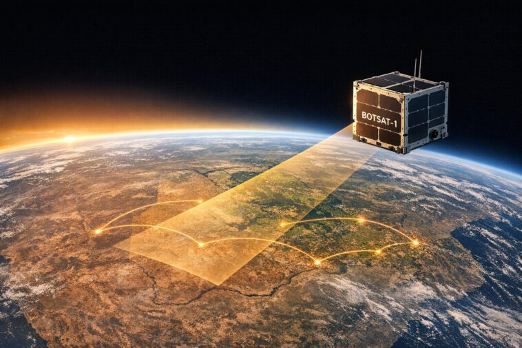
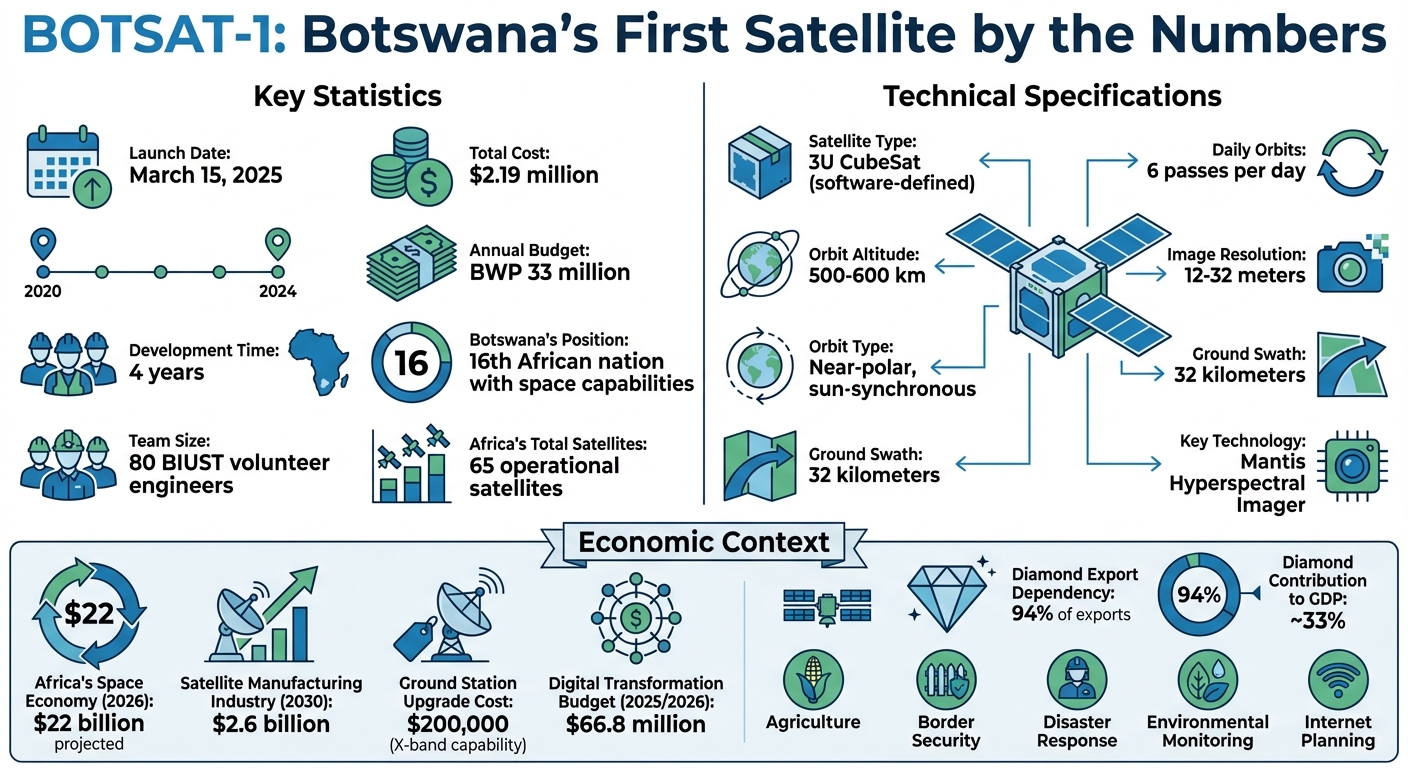
Botswana made history on March 15, 2025, by launching its first satellite, BOTSAT-1, aboard a SpaceX Falcon 9 rocket. This achievement places Botswana among 16 African nations with space capabilities, advancing national goals in agriculture, disaster response, and security. Developed by local engineers at Botswana International University of Science and Technology (BIUST) in collaboration with global partners, the project cost $2.19 million and took four years to complete. Key features include:
- Hyperspectral Imaging: The Mantis Imager provides high-resolution data for monitoring crops, water, and air quality.
- Daily Earth Passes: Six daily orbits at 12-meter resolution enable real-time data collection.
- Ground Station at BIUST: Direct data transmission supports policymaking and research.
Beyond environmental and agricultural uses, BOTSAT-1 strengthens border monitoring, tracks illegal resource extraction, and enhances disaster preparedness. The satellite also supports Botswana’s plans to improve rural internet connectivity and expand its space program with BOTSAT-2. This milestone highlights Botswana’s growing role in Africa’s $22 billion space industry while fostering local expertise and economic diversification.


BOTSAT-1 Key Statistics and Technical Specifications
BOTSAT-1: Technical Specifications and Mission Goals
Main Features of BOTSAT-1
BOTSAT-1, Botswana’s first software-defined satellite, is a 3U CubeSat designed with flexibility in mind. Its architecture, powered by EnduroSat‘s SpaceOps software, enables BIUST engineers to remotely adjust mission parameters as needed.
The satellite’s standout feature is the Mantis Hyperspectral Imager, developed by Dragonfly Aerospace in South Africa. This sophisticated imager captures light across multiple bands in the visible and near-infrared spectrum, making it ideal for analyzing ground materials, vegetation health, water quality, and air conditions. With a spatial resolution between 12 and 32 meters and a ground swath of 32 kilometers, it is a powerful tool for environmental monitoring.
BOTSAT-1 orbits Earth in a near-polar, sun-synchronous orbit at an altitude of 500–600 km (310–373 mi), completing six orbits daily. Data collected by the satellite is transmitted directly to a dedicated ground station located at BIUST’s campus in Palapye, Botswana.
"The Mantis Hyperspectral Imager will provide the advanced imaging capabilities needed to support critical environmental and research applications, strengthening Africa’s Earth observation capacity."
This quote from Francois Mostert, CEO of Cameras at Dragonfly Aerospace, highlights the satellite’s role in advancing Earth observation capabilities in Africa. The development of BOTSAT-1 represents a significant technical achievement for Botswana.
Development Timeline
The BOTSAT-1 project reflects Botswana’s dedication to building its national space program. Conceptualized in 2020, the satellite was developed over four years, culminating in a partnership announcement with Bulgarian manufacturer EnduroSat on July 3, 2024. By August 2024, the satellite’s structure was completed, and the Assembly, Integration, and Testing (AIT) phase was successfully finalized in September 2024 in Sofia, Bulgaria.
The project also prioritized training for local engineers. Under the guidance of Dr. Dimane Mpoeleng and Dr. Modisa Mosalaosi, BIUST engineers worked closely with EnduroSat teams in Sofia, gaining hands-on experience in satellite assembly and payload integration.
Remarkably, the entire project was completed under the allocated annual budget of BWP 33 million. Reflecting on the collaboration, Professor Otlogetswe Totolo, Vice Chancellor of BIUST, noted:
"This partnership brings us closer to realizing our shared vision and underscores the strength of our mutual commitment to advancing space technology in Botswana."
Improving Internet Connectivity in Botswana
Current Connectivity Problems
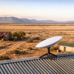
Botswana is grappling with a noticeable digital divide, particularly between urban centers and rural areas. The high costs of building infrastructure in remote regions have left terrestrial ISPs unable to provide adequate services. As of the first quarter of 2025, terrestrial ISPs in Botswana offered a median download speed of just 9.36 Mbps – far below the speeds necessary to support modern digital services.
Enter BOTSAT-1, a satellite designed to address this challenge by enabling data-driven planning. It captures 12-meter resolution images across a 32-km swath and scans Botswana six times daily. These real-time images are transmitted directly to the ground station at the Botswana International University of Science and Technology (BIUST), giving policymakers highly accurate insights into connectivity gaps and underserved areas.
"This satellite would show high-resolution images on the surface that would provide accurate data to inform policymakers." – David Tshere, Minister of Communications and Innovation
While BOTSAT-1 itself does not provide internet services, it plays a critical role in supporting the mission of BOTSAT-2, which aims to deliver faster and more reliable connectivity. The data from BOTSAT-1 helps guide network expansion strategies and lays the groundwork for broader economic development in rural areas.
Rural Development Benefits
Once connectivity gaps are identified, improved internet access has the potential to transform rural communities. Reliable internet can open doors to digital commerce, online education, and telehealth services, making a tangible difference in people’s lives. The data gathered by BOTSAT-1 helps justify investments in these areas by identifying agricultural zones, natural resources, and population hubs that stand to benefit the most from enhanced connectivity.
Additionally, the satellite’s hyperspectral imaging supports key national development goals, such as monitoring crop health and managing water resources. These insights strengthen the case for expanding digital infrastructure in rural areas. As Botswana gears up for the launch of BOTSAT-2, the information from BOTSAT-1 will play a crucial role in determining where new communication systems should be deployed and which ground stations need upgrades to handle the anticipated increase in bandwidth demand.
Developing Space Technology Expertise
National Capacity Building
BOTSAT-1 has been a game-changer in building Botswana’s engineering capabilities. From July 2024 to March 2025, a team of Botswana engineers, led by Project Lead Dr. Dimane Mpoeleng and Lead Engineer Dr. Modisa Mosalaosi, joined forces with EnduroSat teams in Sofia, Bulgaria. During this period, they gained invaluable hands-on experience in satellite assembly, integration, and testing (AIT) processes. By March 2025, Dragonfly Aerospace stepped in to design a cutting-edge clean-room facility at BIUST, which now serves as a hub for satellite assembly and testing. Dragonfly Aerospace also supplied a 3U satellite structure for training purposes, further enriching the learning experience.
BIUST operates a fully functional ground station capable of real-time data reception and is preparing for an upgrade to X-band capabilities, projected to cost around $200,000. The scale of the project is impressive: approximately 80 BIUST volunteers simulated the operations of a space agency, covering everything from administrative and legal tasks to engineering roles. This initiative also led to the launch of a Space Engineering & Technology qualification program in October 2024, along with international exchange opportunities through a Master’s Program in Space Engineering.
The expertise gained from BOTSAT-1 is already being put to work on BOTSAT-2. With the new clean-room facility in place, future satellite assembly will now be conducted entirely within Botswana.
"EnduroSat played a key role in developing Botswana’s engineering expertise, and through this, the engineers gained practical experience in satellite development, from assembly to mission operations." – Dr. Dimane Mpoeleng, BOTSAT-1 Project Lead
This progress not only strengthens Botswana’s engineering capabilities but also positions the country as a rising player in Africa’s expanding space market.
Africa’s Space Industry Growth
Botswana now joins the ranks of 11 African nations operating Earth Observation satellites, contributing to the continent’s growing space portfolio. As of March 2025, Africa has launched a total of 65 satellites, marking significant strides in the region’s space capabilities. This comes at a time when Africa’s space economy is forecasted to grow to $22 billion by 2026. Additionally, over 70,000 satellite images are now freely accessible to African governments through regional data-sharing partnerships.
The BOTSAT-1 mission also underscores the importance of academic-private partnerships across Africa. For instance, South African companies like Dragonfly Aerospace are playing a pivotal role by providing advanced hardware, such as the Mantis Hyperspectral Imager, and assisting in the development of local infrastructure. Botswana managed to complete the BOTSAT-1 project with remarkable efficiency, staying well within its allocated annual budget.
"The launch of BOTSAT-1 is a defining moment for Botswana. It demonstrates our ability to develop, launch and utilise space technology for national development." – Professor Otlogetswe Totolo, Vice Chancellor, BIUST
With these achievements, Botswana is not only advancing its own space ambitions but also contributing to the collective growth of Africa’s space industry.
National Security Applications
Border Monitoring and Resource Protection
The Mantis Hyperspectral Imager aboard BOTSAT-1 is helping Botswana strengthen its border security and protect its natural resources. By providing high-resolution imagery, the satellite enables real-time monitoring and delivers crucial surveillance data directly to the ground station at BIUST.
This hyperspectral technology is especially effective in combating illegal activities tied to natural resources, such as the smuggling of ivory and rhinoceros horn – issues that pose both legal and security challenges for the country. The satellite can detect unique spectral signatures from disturbed landscapes, making it possible to identify illegal mining operations and resource extraction that might otherwise remain hidden.
To further enhance these efforts, the government is working on a national space policy and plans to establish a dedicated space agency. This initiative aims to streamline the integration of satellite data into the country’s broader security framework. The BIUST ground station plays a pivotal role as a centralized hub, ensuring that Earth observation data is readily available to defense and emergency response teams for quick, informed decision-making. Beyond border security, this capability also strengthens Botswana’s disaster preparedness efforts.
Disaster Response Capabilities
BOTSAT-1 is a game-changer for Botswana’s ability to handle natural disasters. Its real-time data significantly improves early warning systems for floods, droughts, and wildfires, which are critical during the wet season (November to March) when heavy rains can lead to flash floods, disrupting infrastructure and emergency services.
With six near-polar passes every day, the satellite provides high-resolution data that is invaluable for tracking border activities and monitoring environmental changes. This constant surveillance allows emergency planners to identify shifting weather patterns and environmental risks before they develop into full-blown crises. Additionally, a $200,000 upgrade to X-band capability is in the works, which will enable faster image downloads. This upgrade ensures emergency teams receive the data they need exactly when they need it, aligning with Botswana’s technological development goals and improving disaster response strategies.
sbb-itb-dd089af
Agriculture and Environmental Uses
Agricultural Applications
The Mantis Hyperspectral Imager aboard BOTSAT-1 is transforming farming in Botswana. With its 12-meter (39 ft) resolution and 32-kilometer (20 mi) swath, the satellite provides highly detailed spectral data that helps farmers detect crop diseases, drought stress, and nutrient deficiencies early – key for protecting yields.
The satellite also keeps tabs on soil moisture, composition, and temperature, guiding farmers in optimizing irrigation schedules and soil treatments. Thanks to the dedicated ground station at BIUST, data from BOTSAT-1’s six daily orbits is readily accessible, giving agricultural planners the tools they need for precision farming.
"BOTSAT-1 will directly benefit local agriculture and mining industries by using the onboard hyperspectral camera payload to provide key intelligence on the contents of grounds and soils." – EnduroSat
But the satellite’s capabilities go beyond agriculture, offering critical insights for broader environmental monitoring.
Environmental Tracking
BOTSAT-1 also plays a vital role in tracking environmental changes, aiding sustainable land management. Its hyperspectral imaging creates detailed "spectral fingerprints" of Botswana’s landscape, enabling the monitoring of deforestation, wildlife habitats, and the effects of climate change. The satellite’s sun-synchronous orbit ensures consistent, daily observations, making it easier to spot environmental changes over time.
Wildlife conservation efforts gain a significant boost from this technology. By combining hyperspectral data with Geographical Information Systems (GIS), conservationists can produce detailed maps that reveal land-use patterns, vegetation health, and shifts in the environment. These tools help teams protect Botswana’s natural heritage while advancing sustainable development initiatives.
"Botswana’s first Earth Observation satellite (BOTSAT-1) originated from three critical national development priorities: environmental conservation, food security, and urban planning." – Space in Africa
In unison, BOTSAT-1’s agricultural and environmental tracking capabilities strengthen food security and support environmental resilience, showcasing the satellite’s pivotal role in Botswana’s development journey.
Economic Benefits and Growth Opportunities
Local Economic Growth
The success of BOTSAT-1 highlights how space technology can drive Botswana’s technological and economic ambitions while opening up new financial opportunities. By commercializing satellite data, BOTSAT-1 not only helps fund the development of BOTSAT-2 but also reduces reliance on grants and attracts private sector investment.
For the 2025/2026 fiscal year, Botswana has allocated $66.8 million (966.37 million pula) to digital transformation efforts, signaling a move to diversify its economy, which currently depends on diamonds for 94% of its exports. The satellite’s hyperspectral imaging capabilities are particularly valuable, providing detailed ground composition data that can enhance efficiency in the diamond industry – responsible for nearly a third of the nation’s GDP – while also supporting the growth of emerging, tech-focused resource management sectors.
These investments set the stage for Botswana to establish a foothold in the expanding global space economy.
Global Space Economy Participation
Beyond domestic advancements, Botswana is stepping into the global space market. The country is positioning itself to claim a share of Africa’s growing space sector, which is projected to reach $22 billion by 2026. Across the continent, the satellite manufacturing and launch industry is valued at $2.6 billion through 2030. Currently, less than 1% of satellite component revenue comes from African customers, pointing to significant opportunities for local sourcing and production.
Botswana has also forged partnerships with global players like SpaceX, EnduroSat, and Dragonfly Aerospace, integrating itself into the international space supply chain. Plans to establish a dedicated space hub aim to centralize space engineering, technology qualification programs, and satellite operations, creating a magnet for both regional and international investors. Combined with Botswana’s top-tier sovereign credit rating in Africa (BBB+/A-2), low tax rates, absence of foreign exchange controls, and expedited Special Economic Zones, the country presents an appealing environment for investment.
"This partnership brings us closer to realizing our shared vision and underscores the strength of our mutual commitment to advancing space technology in Botswana."
- Otlogetswe Totolo, Vice Chancellor, BIUST
Botswana’s satellite program also positions the country as a regional leader in data services. As a member of SACU, SADC, and AfCFTA, Botswana has access to a market of 1.4 billion people, enabling it to export space technology and data services across the continent. With its growing expertise in satellite operations and its strategic regional ties, Botswana is well-poised to emerge as a hub of technological innovation for Africa.
🚀 LIVE: Botswana’s First Satellite BOTSAT-1 Launch | SpaceX Falcon 9 Mission 🌍🔴
Conclusion
The launch of BOTSAT-1 on March 15, 2025, represents a major step forward in Botswana’s technological journey. With a budget of just $2.19 million and the dedication of 80 volunteer engineers, this remarkable achievement came even before the establishment of a formal space agency or policy framework in the country. By joining the ranks of African nations with space capabilities, Botswana contributes to the continent’s total of 65 operational satellites.
Equipped with hyperspectral imaging technology, BOTSAT-1 delivers essential data for agriculture, real-time border monitoring, disaster response, and environmental management. This mission has also laid the groundwork for future advancements, including plans to build ISO-rated clean room facilities at BIUST, enabling the assembly of BOTSAT-2 within Botswana.
"The launch of BOTSAT-1 is a defining moment for Botswana. It demonstrates our ability to develop, launch and utilise space technology for national development." – Professor Otlogetswe Totolo, Vice Chancellor, BIUST
Looking ahead, Botswana is set to expand its space program and strengthen its presence in the global space industry. Collaborations with SpaceX, EnduroSat, and South Africa’s Dragonfly Aerospace have already positioned the nation as part of the international space supply chain. As work begins on BOTSAT-2 and efforts to formalize a national space policy gain momentum, the success of BOTSAT-1 serves as a model for advancing technological independence, diversifying the economy, and establishing leadership within Africa’s growing space sector.
FAQs
How will BOTSAT-1 improve internet access in rural areas of Botswana?
BOTSAT-1 is set to transform internet access in rural Botswana by establishing stronger infrastructure for connectivity in remote areas. This satellite aims to create more dependable communication networks, narrowing the gap between urban and rural regions in terms of digital access.
Beyond just connectivity, BOTSAT-1 plays a role in several fields, including precision agriculture, disaster management, and urban planning – all through the delivery of real-time data. These capabilities don’t just enhance daily life; they open doors for economic development and new opportunities in communities that have historically been left behind.
How does Botswana’s first satellite, BOTSAT-1, enhance national security?
BOTSAT-1 brings Botswana a major boost in national security by enhancing surveillance and monitoring efforts. With its ability to provide real-time data, the satellite helps keep an eye on borders, track land usage, and identify illegal activities like smuggling or unapproved resource extraction. These capabilities significantly improve the country’s readiness to address security challenges.
The satellite also plays a key role in disaster response. By delivering up-to-the-minute information during natural or man-made crises, it helps protect both citizens and essential infrastructure. With this leap into satellite technology, Botswana is not only strengthening its security and resilience but also carving out a prominent position in Africa’s expanding space sector.
How will BOTSAT-1 drive Botswana’s economic growth and innovation?
BOTSAT-1 marks a significant milestone for Botswana, paving the way for economic development and technological progress through advanced satellite technology. Equipped with hyperspectral imaging capabilities, it delivers highly detailed data that benefits industries like mining and agriculture. For Botswana – a global leader in diamond production and a growing player in agriculture – this means smarter resource extraction and improved monitoring of environmental conditions.
Beyond that, the satellite plays a crucial role in areas such as disaster management, urban development, and environmental monitoring. These advancements not only open doors for new industries but also create job opportunities. Built with contributions from local engineers and strengthened by international partnerships, BOTSAT-1 positions Botswana as an emerging leader in Africa’s space sector, while helping the country diversify its economy beyond traditional resource-based industries.
Related Blog Posts
- Starlink Partners with Airtel & Vodacom: From Rival to Ally
- South Africa’s DA Pushes for Starlink Entry to Boost Connectivity
- Airtel Africa to Launch ‘Direct-to-Cell’ Satellite Service in 2026
- Vodacom Integrates Satellite Tech to Reach Rural South Africa